Inconsistent borehole logs cost your team time, credibility, and confidence in final reports. When each field engineer records soil descriptions differently, when depth intervals shift between projects, and when classification codes vary across offices, the entire reporting chain breaks down. Standardizing your borehole logging workflow from field capture through final geotechnical reports eliminates these problems at their source.
This guide walks you through every stage of that standardization process. You will learn how to build consistent field capture protocols, align your team around classification standards, implement quality assurance checkpoints, and produce defensible geotechnical reports that hold up under client and regulatory review.
Key Takeaways: Standardizing Borehole Logging Workflows
- Standardized borehole logging reduces transcription errors and accelerates report turnaround across your entire team.
- Adopting a single classification system such as USCS or BS5930 keeps soil descriptions consistent between projects.
- Quality assurance checkpoints during field capture catch errors before they reach the reporting stage.
- Classification standards enforced at the point of capture, through structured, button-driven field entry, remove the guesswork that causes drift between technicians.
- Connecting field data directly to your reporting workflow eliminates redundant data entry and protects audit trails.
Why Does Borehole Logging Standardization Matter?
Standardization matters because inconsistency at the logging stage cascades through the entire project. If one technician logs a stratum as "sandy CLAY, medium plasticity, firm" and another records the same material as "CLAY with sand, stiff," your cross-sections and bearing capacity calculations carry conflicting assumptions.
A standardized workflow locks in how your team describes, records, and validates borehole data. It establishes terminology rules, depth recording conventions, and QA/QC triggers that apply to every borehole on every project.
What Are the Core Components of a Standardized Borehole Log?
Borehole Identification and Location Data
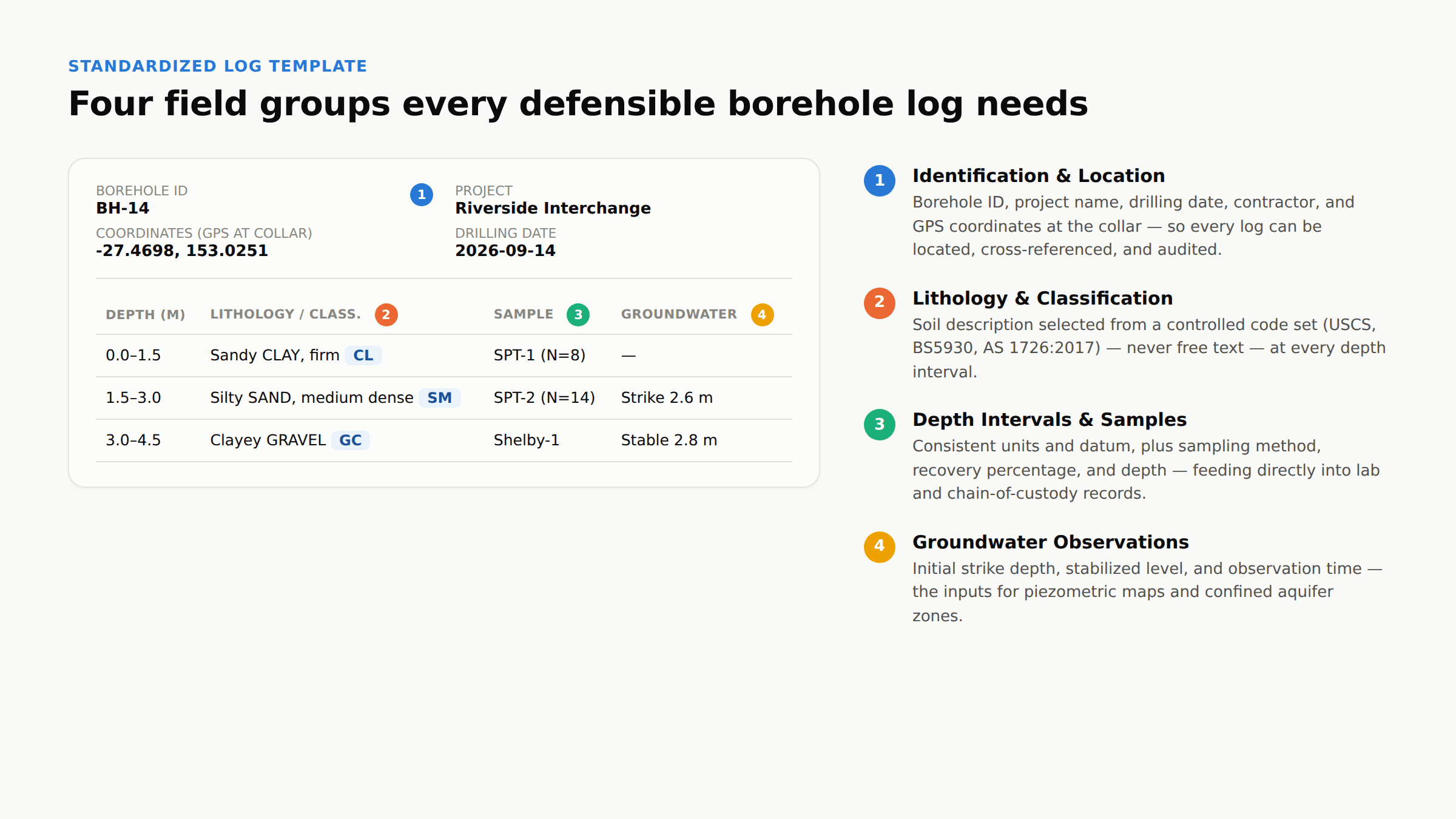
Every standardized log begins with consistent identification. This includes a unique borehole ID, project name, drilling date, contractor name, and GPS coordinates. Maintaining a naming convention across your firm ensures that each borehole can be located, cross-referenced, and audited.
Location accuracy directly affects geological interpretation. Errors in northing, easting, or ground surface elevation distort your cross-sections and subsurface models. Recording coordinates with GPS at the collar is the most reliable approach.
Lithology Descriptions and Soil Classification
Lithology descriptions are where inconsistency typically enters the workflow. Two geologists examining the same sample may choose different primary descriptors, adjectives, or grain-size qualifiers.
Standardizing lithology means adopting a fixed classification system and enforcing its terminology at every depth interval. Your field staff should not have free-text entry for soil type when a controlled vocabulary exists. Fixed selection lists tied to USCS, BS5930, AS 1726:2017, or ASTM D2487 codes prevent drift.
Depth Intervals and Sample Records
Depth intervals define where each geological layer starts and ends. Consistent measurement units and recording conventions are essential. Your entire team must record depths in the same unit (meters or feet) and use the same reference datum (ground level or top of casing).
Sample records should capture sampling method (SPT, Shelby tube, grab), recovery percentage, and the depth at which each sample was collected. These records feed directly into laboratory testing schedules and chain-of-custody documentation.
Groundwater Observations
Groundwater data is critical for foundation design, dewatering analysis, and environmental site assessment. Your standardized log template should include fields for initial water strike depth, stabilized water level, and the time of each observation.
Recording groundwater conditions consistently across your project allows you to build accurate piezometric maps and identify confined aquifer zones with confidence.
How to Choose and Enforce a Soil Classification System
Your classification system anchors every description on every log your firm produces. The most common systems include USCS (ASTM D2487), the British Standard BS5930, the Australian Standard AS 1726:2017, and Eurocode 7. Each system defines specific group symbols, grain-size boundaries, and plasticity criteria.
Choosing one system is straightforward. Enforcing it is the challenge. When your field team can type free-text descriptions, classification drift is inevitable. A technician who typed "silty SAND" on Monday may type "SAND with silt" on Thursday, and both entries may be technically correct under the standard but create inconsistency in your database.
The enforcement mechanism should be structural. Button-driven or dropdown-based entry tied to your chosen standard's code list eliminates free-text variability. At the point of capture, field entry restricted to pre-configured code sets aligned with USCS, BS5930, or AS 1726:2017 means your field geologist selects from a fixed classification set rather than typing a description.
How to Build a Standardized Field Capture Workflow
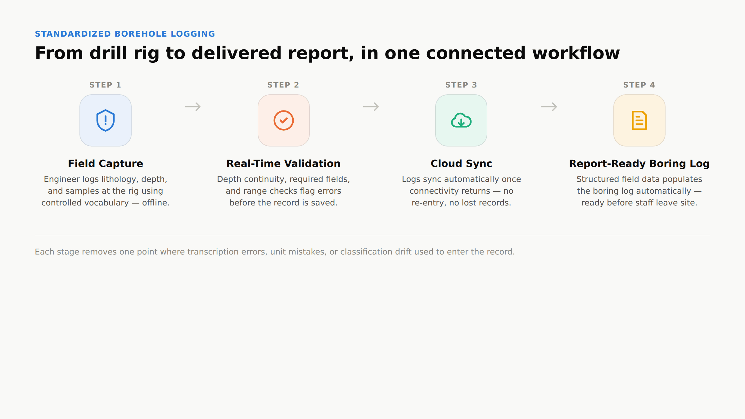
Step 1: Define Your Logging Template Your logging template is the backbone of standardization. It should include every required field for your typical project scope: borehole ID, coordinates, elevation, drilling method, bit size, casing depth, lithology at each interval, SPT N-values, sample type, recovery, moisture content, and groundwater observations.
Lock your template to your firm's standard, then distribute it across all field teams. When the template itself enforces required fields, engineers cannot skip critical data points.
Step 2: Assign Controlled Vacabulary to Every Field Anywhere your template accepts descriptive input, replace free text with a controlled vocabulary. Colour descriptions should pull from a fixed list (Munsell or simplified colour set). Consistency ratings should map to defined terms (very soft, soft, firm, stiff, very stiff, hard). Grain-size modifiers should follow your adopted classification code.
Controlled vocabulary is the single most effective step you can take to prevent logging inconsistency. It removes the subjective judgment that causes the most variation between field engineers.
Step 3: Configure Validation Rules Validation rules catch errors at the moment they occur. Typical rules include depth interval continuity checks, required field enforcement, and range validation for SPT blow counts. If a technician tries to enter an SPT N-value of 300, the system should flag it before the record is saved.
Real-time validation is more effective than post-collection QA because it prevents errors from reaching your database. By the time a project manager reviews a log in the office, the field crew may have moved to the next borehole, and correcting the error requires re-interpretation rather than direct observation.
Step 4: Enable Offline Field Logging with Automatic Sync Many geotechnical drilling sites lack reliable connectivity. Your field capture tool must operate fully offline and sync automatically when a connection becomes available. This protects data integrity on remote sites and eliminates the risk of lost records.
Offline field logging with automatic synchronization once connectivity returns lets your field staff complete logs at the drill rig, while office teams review the data as soon as it syncs.
What Role Does Terminology Consistency Play in Geotechnical Data Management?
Terminology consistency is the connective thread running through borehole logging, data management, and final reporting. When your entire organization describes the same soil as "CL" rather than a mix of "lean clay," "clay, low plasticity," and "CL-lean clay," your geotechnical database becomes searchable, filterable, and reusable.
Consistent terminology also protects your firm during disputes. If a report is challenged, the ability to trace a specific classification back to a specific borehole, depth, technician, and date demonstrates defensibility. An audit trail with conflicting terminology across logs weakens that position.
A 2025 study on geotechnical core logging QA/QC, presented through the Australian Centre for Geomechanics, found that delayed error review, sometimes occurring days or weeks after data is collected in the field, allows mistakes to compound through every later stage of a project (Veltin et al., 2025). The same dynamic applies to borehole logging on infrastructure projects: the longer an inconsistency sits undetected, the more expensive it becomes to trace and correct.
How to Implement QA/QC Checkpoints from Field to Report
Field-Level QA: Validation at the Point of Capture
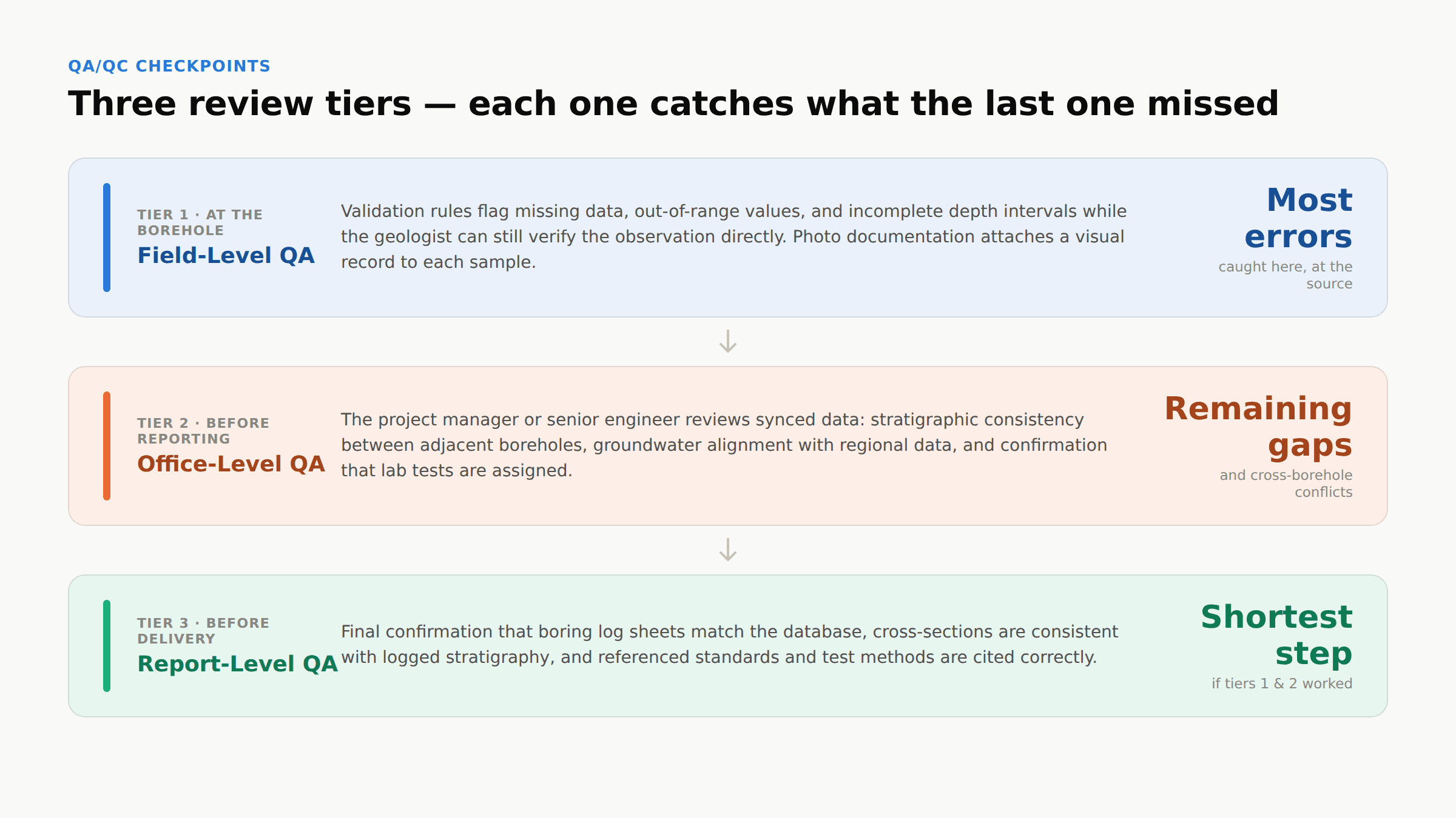
Your first QA checkpoint occurs in the field. Validation rules built into your logging tool should flag missing data, out-of-range values, and incomplete depth intervals before the technician moves to the next borehole. This is the most cost-effective place to catch errors because the geologist is still at the borehole and can verify the observation directly.
Field-level QA also includes photo documentation. Attaching a timestamped photograph of each sample core or split spoon to its depth record creates a visual audit trail that supports the written description.
Office-Level QA: Review Before Reporting
Office QA occurs when the project manager or senior engineer reviews synced field data before it enters the report. This review should check for stratigraphic consistency between adjacent boreholes, verify that groundwater observations align with regional data, and confirm that all required laboratory tests have been assigned.
A structured review dashboard that shows outstanding tasks, missing lab results, and flagged entries accelerates this step. Real-time visibility into investigation status across all active sites means project managers can identify data gaps early instead of discovering them during report production.
Report-Level QA: Final Checks Before Delivery
Your final QA checkpoint confirms that the report accurately reflects the reviewed dataset. This means verifying that boring log sheets match the database records, that cross-section interpretations are consistent with the logged stratigraphy, and that all referenced standards and test methods are correctly cited.
Report-level QA should be the shortest step in your workflow. If your field and office QA checkpoints are working, most errors will have been resolved before the report stage.
How to Connect Field Data to Final Geotechnical Reports
The gap between field data and final reports is where most geotechnical firms lose time and introduce errors. In a non-standardized workflow, someone in the office re-enters field observations from handwritten notes or PDFs into a report template. Each re-entry point is an opportunity for transcription errors, unit conversion mistakes, and classification drift.
A standardized workflow eliminates re-entry by connecting your field capture tool directly to your report generation system. When the data entered at the drill rig populates the boring log sheet automatically, you remove the most common failure point in the reporting chain.
Report-ready boring logs generated directly from structured field data mean your field engineers log at the rig, and the logs are ready for review before staff even return to the office. Teams that make this switch consistently report spending far less time on office-side QA/QC, since most errors are caught and resolved before the data ever reaches a desk.
What Standards Apply to Borehole Logging Worldwide?
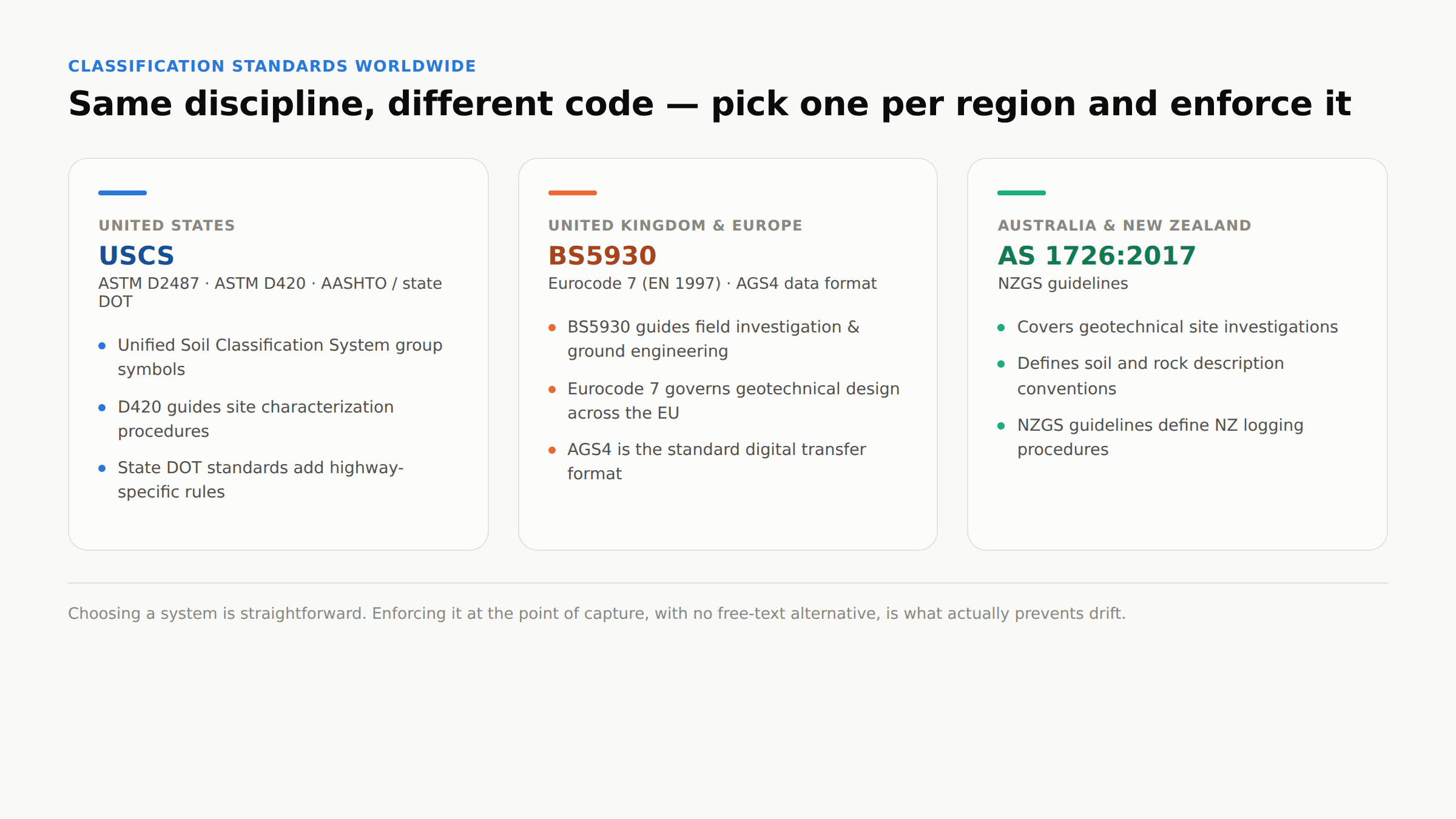
United States: ASTM D2487 and USCS
In the US, ASTM D2487 defines the Unified Soil Classification System (USCS) used for geotechnical engineering. ASTM D420 covers site characterization procedures, and AASHTO and state DOT standards add project-specific requirements for highway and infrastructure projects.
United Kingdom and Europe: BS5930 and Eurocode 7
BS5930 guides field investigation and ground engineering in the UK. Eurocode 7 (EN 1997) governs geotechnical design across the European Union and defines requirements for site investigation reporting. AGS4 is the UK's standard digital data transfer format for ground investigation data.
Australia and New Zealand: AS 1726:2017 and NZGS Guidelines
The Australian Standard AS 1726:2017 covers geotechnical site investigations, including soil and rock description. In New Zealand, the NZGS (New Zealand Geotechnical Society) guidelines define logging procedures that many firms follow.
Regardless of your operating region, aligning your logging workflow with the applicable standard is a prerequisite for standardization. Your field entry tool should be configured to enforce the specific classification code set required by your standard.
How to Manage Multi-Site and Multi-Rig Borehole Logging Programs
On large-scale programs with multiple drilling rigs operating across different sites, standardization becomes even more critical. Each rig generates data independently, and if those rigs are using different templates, terminology, or classification approaches, the resulting dataset is inconsistent and difficult to merge.
A centralized, cloud-based workflow solves this by distributing the same logging template and controlled vocabulary to every rig. Field data from all sites syncs to a single project database, and your project manager can review incoming logs from any location in real time.
Centralized project dashboards give you multi-site program oversight across multiple rigs: you can monitor logging progress, review completed boreholes, and identify data gaps across your entire investigation program from a single view.
How to Transition from Non-Standardized to Standardized Borehole Logging\
Phase 1: Audit Your Current Workflow Start by documenting how your team currently captures, stores, and reports borehole data. Identify where inconsistency enters the process: which fields allow free text, which classification system each office uses, and how data moves from field to report. This audit establishes your baseline.
Phase 2: Select Your Standards and Build Templates Choose a single classification system and define your firm-wide logging template. Document every required field, controlled vocabulary list, and validation rule. This template becomes your standard operating procedure for all future investigations.
Phase 3: Train Your Field and Office Teams Roll out the new template with hands-on training. Field geologists need to understand why controlled vocabulary matters and how to use the new logging interface. Office engineers need to know how to review synced data and run QA checks. Training should include worked examples using real project data.
Phase 4: Pilot on a Live Project Run the standardized workflow on a single project first. Monitor for pain points: fields that need adjustment, validation rules that are too strict, or controlled vocabulary entries that are missing. Refine the template based on pilot feedback before rolling out to all projects.
Phase 5: Scale and Monitor Once the pilot succeeds, deploy the workflow across your organization. Monitor adoption through database consistency metrics: are all logs using the same classification codes? Are depth intervals recorded in the correct unit? Are validation rules catching errors?
What Are Common Borehole Logging Errors and How to Prevent Them?
The most common errors in borehole logging fall into a few categories. Inconsistent lithology descriptions top the list. When geologists type soil descriptions rather than selecting from a fixed list, terminology varies between individuals and across projects.
Inaccurate depth measurements are the second most common error. These can result from incorrect driller's depth readings, reference datum confusion, or simple recording mistakes. Validation rules that check depth interval continuity catch most of these at entry.
Missing sample records create problems during lab coordination and chain-of-custody tracking. If a sample collected at 4.5 m is not logged, it may be tested without proper documentation, which compromises the defensibility of the result.
Prevention relies on three controls: structured entry (no free text), real-time validation (immediate feedback), and mandatory fields (cannot proceed without completing required entries).
How Does Borehole Log Standardization Improve Report Defensibility?
Defensible geotechnical reports require traceability. A reviewer or regulator should be able to trace any value in the report back to its source: which borehole, which depth, which technician, which date, and the original unedited observation.
Standardized logging builds this traceability into every record. When your classification code is selected from a controlled list rather than typed, the original entry is unambiguous. When your validation rules enforce depth continuity and required fields, there are no gaps in the record.
This matters most during peer review, regulatory audits, and legal proceedings. A standardized, timestamped audit trail demonstrates that your firm followed consistent procedures and that the data was captured, validated, and reported with professional rigor.
How to Standardize Borehole Logging for Your Team
Standardizing your borehole logging workflow requires deliberate decisions about classification systems, controlled vocabulary, field capture tools, QA/QC checkpoints, and report generation. Each decision reinforces the next, and the result is a workflow that produces consistent, defensible geotechnical data from the first borehole through the final report.
Start with the biggest source of inconsistency in your current process. For most firms, that is free-text soil descriptions. Lock those down with a controlled classification set, then work through the rest of the workflow: depth conventions, validation rules, review processes, and automated report generation.
TabLogs gives your team the structured, cloud-based workflow needed to enforce standards at the point of capture and deliver report-ready boring logs from the field. Book a discovery call to see how it works for your projects.
FAQs About Standardizing Borehole Logging Workflows
What is the most common cause of inconsistent borehole logs?
Free-text data entry is the primary cause. When field engineers type soil descriptions manually, terminology varies between individuals and projects. Controlled vocabulary entry tied to a fixed classification code set eliminates this variability.
Which soil classification system should I use for borehole logging?
Your choice depends on your operating region and project requirements. USCS (ASTM D2487) is standard in the United States. BS5930 applies in the UK. AS 1726:2017 governs Australian projects. Choose one system and enforce it across your entire team.
How does TabLogs enforce borehole logging standards?
By restricting field entry to pre-configured classification code sets. Your field team selects soil descriptions from structured, button-driven menus rather than typing, so every log follows the same terminology and classification rules.
Can I standardize borehole logging across multiple offices?
Yes. A cloud-based platform distributes the same logging template, controlled vocabulary, and validation rules to every field team, so all offices and field crews work from a single standard regardless of location.
How long does it take to transition to a standardized logging workflow?
A pilot project on the new workflow typically takes a few weeks to run. Full organizational rollout depends on the number of offices and active projects, but most firms complete it within a few months with proper training and support.
What is the role of QA/QC in standardized borehole logging?
QA/QC ensures that your standards are being followed at every stage. Field-level validation catches errors during data entry. Office-level review verifies consistency between boreholes. Report-level QA confirms that the final deliverable matches the validated dataset.
Does standardization affect field logging speed?
Structured entry with controlled vocabulary and button-driven interfaces is typically faster than handwritten or free-text logging, and report-ready boring logs being available before field staff return to the office accelerates both data capture and reporting.