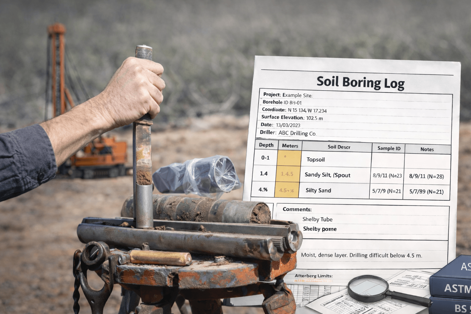
Geotechnical firms working across the US, Canada, and the UK run into the same problem: a boring log written in one country doesn't read the same way in another. USCS symbols get assigned differently under ASTM D2487 versus a BS 5930 field description. An "N value" in a US log and a "penetration index N" under CAN/BNQ 2501-140 aren't always recorded the same way, even when the test itself is identical. None of this is a soil problem. It's a terminology and standards problem, and it shows up the moment two crews, two contractors, or two offices try to compare logs side by side.
This guide is built to close that gap. It covers how ASTM D2487, ASTM D2488, BS 5930, and CAN/BNQ 2501-140 each shape what goes on a boring log and how it gets read, with copy-paste templates for each region and a single worked example showing one soil layer logged three different ways, so your team can see exactly where the differences are and standardise around them.
Along the way, we will reference the most commonly cited standards for soil description and classification in these markets:
- ASTM D2487 USCS soil classification - for when a precise classification is required.
- ASTM D2488 visual manual soil description and identification, with clear reporting that the symbol is based on visual manual procedures.
- BS 5930 as the UK code of practice for ground investigations, updated by BSI and widely used for planning and reporting expectations.
- A Canada specific reference point for SPT procedure and the penetration index N, such as CAN/BNQ 2501-140.
You will also get copy and paste templates you can use immediately, plus a simple “one layer, three regions” translation example so your team stops arguing about terminology and starts producing consistent logs.
Page Glossary (plain language)
| Term | Plain language meaning | What to record on the log |
|---|---|---|
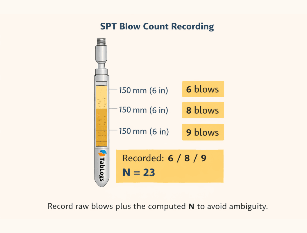
| SPT N | The Standard Penetration Test result, commonly reported as the number of hammer blows needed to drive the sampler a set distance. People often say “N value” as shorthand for this. | Record the raw blows by increment (for example 6/8/9) and the final N you report. Add notes for refusal or unusual conditions. |
| Penetration index N | A defined way of reporting the SPT result within a specific test standard or procedure. In some Canadian contexts, “penetration index N” is used as the named outcome of the SPT method. | Record the same raw blows and N, and also note the method or standard used so the meaning stays consistent across regions. |
| USCS | Unified Soil Classification System. A standard way to label soils using group symbols like CL, SM, GP based on particle size distribution and plasticity. | If field based, label it as visual manual identification. If lab confirmed, store the final group symbol tied to lab results. Keep both if possible. |
| Boundary types | A simple way to describe how confident and how abrupt a change is between two layers. | Use one term for each contact: sharp (sudden change), clear (distinct), gradational (changes over a short depth), inferred (estimated between samples). |
What counts as a boring log, and why that varies by standard
A soil boring log is the primary record of subsurface conditions observed and sampled during drilling. It captures what happened at the rig, what materials were encountered, what samples were taken, what tests were performed, and what groundwater conditions were observed.
A good boring log does two things at the same time:
- It stands on its own as a defensible field record
- It converts cleanly into structured data for modelling, design, and reporting
- If your log only does the first, you end up with messy spreadsheets and one off interpretation later. If your log only does the second, you lose the nuance that engineers rely on to manage uncertainty.
The core components of a boring log and how to interpret each one
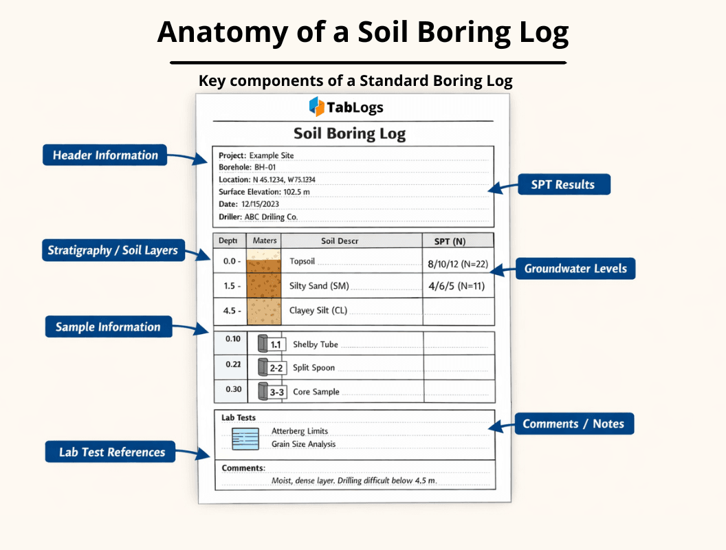
1) Project and hole identification
What to include
- Project name and number
- Borehole ID
- Coordinates and coordinate system
- Datum and surface elevation
- Drilling date and time
- Logger and driller names
- Rig type and drilling method
How to interpret it Start here before you look at anything else. If coordinates, datum, and surface elevation are unclear, every downstream plot and profile becomes suspect. The fastest way to create project wide confusion is to mix datums or coordinate systems without explicitly stating them.
Standardisation tip Create an ID convention that survives export. For example, BH-01, BH-02, TP-01. Avoid names like “South boundary hole” that change meaning when the site plan changes.
 The core sections every defensible boring log should include
2) Drilling method and drilling conditions
What to include
- Method (hollow stem auger, rotary wash, sonic, mud rotary, etc.)
- Casing used or not used
- Drilling fluid details if relevant
- Notes on loss of circulation, heave, caving, refusal, obstructions
How to interpret it Drilling method affects sample disturbance and what you can infer between samples. A clean log makes it obvious where the ground conditions were directly observed versus inferred from cuttings, drilling response, or “feel.”
Standardisation tip Use short controlled terms for drilling issues, plus a notes field for specifics. Example controlled terms: caving, squeezing, heave, obstruction, refusal.
3) Sampling and recovery
What to include
- Sample type (split spoon, Shelby, bulk, core run, etc.)
- Sample ID that links to lab results
- Depth interval for each sample
- Recovery and sample quality notes
- Preservation notes if required
How to interpret it Sampling tells you what data is strong. A high quality undisturbed sample supports strength and compressibility testing. A disturbed split spoon sample supports classification and index properties. A boring log that does not clearly differentiate sample types invites over interpretation.
Standardisation tip Store sample depth “from” and “to” as two separate fields, not one string. Your future self will thank you when you need to filter by depth.
4) Stratigraphy and depth intervals
What to include
- Lithology or soil unit descriptions by depth
- Layer boundaries and thickness
- Boundary confidence if your workflow supports it
- Notes on interbeds, lenses, gradational transitions
How to interpret it Treat layer boundaries as an interpretation of observed data, not as absolute truth. A good log communicates uncertainty. If boundaries are inferred between samples, say so.
Standardisation tip Define interval rules in advance:
- Are boundaries rounded to the nearest 0.1 ft or 0.05 m
- How do you record thin lenses
- What is your minimum reportable thickness
- How do you handle “no recovery”
5) Groundwater observations
What to include
- Seepage during drilling
- Depth to water at time observed
- Stabilised groundwater level if measured later
- Time since drilling and method of measurement
- Whether casing or drilling fluids could affect readings
How to interpret it Groundwater is time dependent. A single “GWL at 3.2 m” with no timing is not enough to interpret perched water, delayed inflow, or seasonal influence. Make timing explicit.
Standardisation tip Always capture:
- Observation type: during drilling, after drilling, standpipe, piezometer
- Timestamp or elapsed time since completion
6) Field description and soil identification
This is where most inconsistency occurs, and it is the easiest place to fix with a standard vocabulary.
What to include
- Soil name and modifiers (with a defined scheme)
- Colour
- Moisture condition
- Density or consistency
- Structure and fabric
- Cementation
- Organics and odor if relevant
- Any unusual features: shells, gravel seams, fill, debris
How to interpret it Field description is not lab classification, but it is still highly valuable. ASTM D2488 explicitly covers description and visual manual identification procedures and makes it clear that reporting should state the symbol is based on visual manual procedures when using the D2487 symbols.
Standardisation tip Split “description” into structured picklists plus a notes field. Example:
- Moisture: dry, moist, wet
- Consistency: very soft, soft, firm, stiff, very stiff, hard
- Density: very loose, loose, medium dense, dense, very dense. Then allow short notes for nuance.
7) In situ test results, including SPT
What to include
- Test type
- Depth of test
- Raw recorded blows per increment if applicable
- Final reported value, such as SPT N
- Notes on hammer type, borehole conditions, and refusal criteria if relevant
For the SPT procedure itself, ASTM D1586/D1586M describes the standard penetration test method and split-barrel sampling.
Interpretation warning “SPT N” can be recorded, discussed, and corrected in different ways depending on local practice. The safest logging approach is to store the raw blows and the computed N so reviewers can understand exactly what was recorded.
Canada note If you are using Canadian terminology, CAN/BNQ 2501-140 explicitly frames SPT output as the penetration index N and is worth citing when you use that term.
Regional standards and how they affect boring logs
United States: ASTM D2487 and ASTM D2488 (USCS)
ASTM D2487 ASTM D2487 describes the USCS classification system and states it is to be used when a precise classification is required, based on laboratory determination of particle size characteristics, liquid limit, and plasticity index.
What that means for your boring logs:
- If you are claiming a D2487 classification, you should be able to tie it to lab results, not just field feel.
- If lab results are pending, you can log a preliminary visual manual ID, but label it clearly as such.
ASTM D2488 ASTM D2488 covers soil description and visual manual identification. It also states that if you use D2487 symbols and names based on visual manual procedures, you should clearly state that in your reporting.
Practical logging approach:
- Record the field description and visual manual ID in the log
- Later update the final USCS classification field when lab data confirms it
- Keep both, do not overwrite history without a trace
United Kingdom: BS 5930 for ground investigation practice
BS 5930 is the UK code of practice for ground investigations and has been revised by BSI, with the 2020 update highlighted by BSI as supporting suitability assessment and best practice recommendations for gathering the right site information.
WHat that means for your boring logs
- UK practice often expects strong linkage between planning, fieldwork, and reporting
- Logging conventions may emphasise the context of investigation, not only the material encountered
- The safest way to work cross region is to keep a consistent data schema, then map regional presentation preferences at report time
Canada: use the right references
A quick but important correction: CSA A283 is not a soil logging standard. It is a CSA standard for certification of laboratories for concrete.
For Canadian practice, you will commonly see ASTM classification used in many contexts, plus Canadian standards and references for testing and broader geotechnical practice. For example:
- CAN/BNQ 2501-140 for SPT procedure and the penetration index N
- Canadian Geotechnical Society references such as the Canadian Foundation Engineering Manual as a widely used Canadian geotechnical reference point
For a Canada-specific geotechnical reference, the Canadian Foundation Engineering Manual is published by the Canadian Geotechnical Society, with the 5th Edition released in October 2023.
How to handle this in your logs:
- Use a consistent classification and description structure
- Make the test method and terminology explicit
- Avoid mixing terms like “N value” without stating whether you mean raw field blows or a defined penetration index within a specific method
Terminology differences that cause the most confusion
N values vs SPT blow counts
In some contexts, people say “N value” when they mean the SPT blow count. In other contexts, “penetration index N” is used in a defined standard method. The fix is simple.
Log both
- Raw blows per increment
- Computed N
- Standard or method reference if your project requires it
This prevents misinterpretation when logs cross borders or get reviewed by a different office.
Soil description vocabulary
The words are the problem, not the soil.
Common sources of inconsistency:
- Moisture terms used inconsistently
- Density and consistency terms mixed together
- “Trace,” “some,” “with,” “and” used without percentages or defined meaning
- Colour omitted or over described
Standardisation move Create a controlled vocabulary list for the fields that matter most, then allow a short free text field for anomalies.
Layer boundaries and “gradational” contacts
In one region, a transition is logged as a single layer with notes. In another, it becomes two layers with a hard boundary. Neither is universally correct.
Standardisation move Add a “Boundary type” field:
- sharp
- clear
- gradational
- inferred
That single field makes profiles far easier to interpret later.
How to read a boring log safely and avoid the classic mistakes
Step 1: Identify what is observation vs interpretation
Observation: sample recovered, colour, moisture, blow counts, recovery, groundwater observed at time X Interpretation: layer boundary at depth Y, inferred unit between samples, correlation between holes
If your log does not separate these, your review should.
Step 2: Check drilling and sampling before trusting classifications
A perfect USCS symbol on a log means little if the sampling method and recovery are unclear. Start with method, then sample quality, then classification.
Step 3: Treat groundwater entries as time stamped data
If you only see one water level with no time, treat it as a field observation, not a design groundwater level.
Step 4: Run a red flags checklist
Red flags worth stopping for:
- Missing datum or coordinate system
- Layer boundaries exactly at sample intervals every time, with no explanation
- SPT N recorded but no raw blows or refusal notes
- Sudden unit change with no sample or test around the boundary
- Groundwater listed with no timing or method
No linkage between sample IDs and lab results
For a widely cited practical reference, FHWA materials point to detailed guidance on boring log completion, soil description, and classification within the FHWA NHI subsurface investigation manual.
How to standardise geotechnical data across crews and regions
This is the part most teams skip. It is also where the time savings and risk reduction live.
Principle 1: Use one data schema, then map to regional output formats
If your underlying fields are consistent, you can generate different report styles without changing how the data is captured.
Minimum recommended schema groups:
- Borehole metadata
- Depth intervals and stratigraphy
- Sample table
- Test results table
- Groundwater observations
- Classification fields
- Notes and attachments
Principle 2: Separate structured fields from narrative notes
Structured fields power comparison, filtering, and export. Notes provide nuance.
Good split:
- Structured: moisture, density, consistency, USCS symbol, percent gravel, boundary type
- Notes: “sandy seam at 3.6 to 3.7 m,” “occasional roots,” “minor gravel lenses”
Principle 3: Standardise depth interval rules
Write this into your SOP and train it once.
Decide:
- Units per project: feet or metres
- Rounding rule: 0.1 ft, 0.05 m, etc.
- Minimum thickness for a separate layer
- How to log no recovery
- How to log core runs versus samples
Principle 4: Standardise SPT capture as raw plus computed
Store:
- blows for each increment
- computed N
- refusal criteria and notes
This makes your logs readable in any market and far easier to QC.
Principle 5: Version control your templates
If templates change, you need to know which version created which logs. Add:
- template version
- revision date
- author or approver
This is boring admin work that saves real money when disputes happen.
Downloadable boring log templates (copy and paste)
Below are three “templates” you can drop into a spreadsheet, database, or software form builder. They are designed to support both standards based logging and clean data export.
Template 1, US focused (ASTM D2487 and D2488 aligned)
Borehole header fields
| Field | Example |
|---|---|
| Borehole_ID | BH-01 |
| Project_ID | 24-123 |
| Date_Start | 2026-03-05 |
| Coordinate_System | State Plane, NAD83 |
| Easting | 1234567 |
| Northing | 7654321 |
| Datum | NAVD88 |
| Surface_Elev | 102.4 ft |
| Drilling_Method | HSA |
| Driller | ABC Drilling |
| Logger | DJ |
Interval table fields
| From_Depth | To_Depth | Material_Description | Visual_ID_USCS | Lab_USCS | Moisture | Density_Or_Consistency | Color | Structure | Cementation | Boundary_Type | Notes |
|---|---|---|---|---|---|---|---|---|---|---|---|
| 0.0 | 2.5 | Sandy SILT with trace gravel | ML | ML | moist | firm | brown | massive | none | clear | fill suspected in top 0.5 ft |
Why this aligns D2488 supports visual manual description and identification, and it is common to use D2487 symbols in the field as long as you clearly state they are based on visual manual procedures, then update with lab confirmed D2487 classification later.
Template 2, UK focused (BS 5930 aligned presentation)
Borehole header fields
| Field | Example |
|---|---|
| Borehole_ID | BH-03 |
| Grid_Ref | TQ 12345 67890 |
| Datum | OS datum |
| Ground_Level | 31.2 m |
| Investigation_Purpose | Foundation assessment |
| Method | Cable percussion |
| Logged_By | DJ |
Interval table fields
| From_m | To_m | Description | Strength_Or_Consistency | Moisture | Fabric_Or_Structure | Discontinuities | Groundwater_Notes | Samples | Notes |
|---|---|---|---|---|---|---|---|---|---|
| 0.0 | 1.2 | Made Ground: sandy gravel with brick fragments | dense | moist | heterogeneous | none | seepage noted at 1.1 m | Bulk S1 | variable |
Why this aligns BS 5930 is a code of practice used to guide ground investigation practice and reporting expectations in the UK, and BSI has highlighted its role in gathering the right site information for design and safety.
Template 3, International template (US, Canada, UK)
This template keeps one schema and supports regional terminology by adding a “Regional_Terms” note field rather than changing your data structure.
Borehole header fields
| Field | Example |
|---|---|
| Borehole_ID | BH-07 |
| Country | Canada |
| Units | m |
| Coordinate_System | UTM Zone 10N |
| Datum | CGVD2013 |
| Surface_Elev | 54.8 |
| Drilling_Method | Rotary wash |
| Standard_References | ASTM D2488, ASTM D2487, CAN/BNQ 2501-140 |
Interval table fields
| From | To | Material_Description | Field_ID_System | Field_ID_Symbol | Lab_Class_System | Lab_Class_Symbol | Test_Ref | SPT_Blows | SPT_N | Groundwater | Boundary_Type | Notes |
|---|---|---|---|---|---|---|---|---|---|---|---|---|
| 3.0 | 4.5 | Silty SAND with gravel | USCS | SM | USCS | SM | CAN/BNQ 2501-140 | 8/10/12 | 22 | none | gradational | penetration index recorded as N |
Why this works
- ASTM D2487 gives a lab based classification framework when a precise classification is required
- ASTM D2488 supports field description and visual manual identification, with clear reporting expectations
- CAN/BNQ 2501-140 explicitly references determining penetration index N in SPT
One soil layer described three ways (US, Canada, UK)
Let’s take a single layer encountered at 2.0 to 3.5 m: a moist, brown, fine to medium sand with some silt, occasional fine gravel, and SPT blows 6, 8, 9.
US style entry
- Description: brown, moist, fine to medium SAND with silt, trace fine gravel
- Field ID (visual manual): SM
- SPT blows: 6/8/9, N = 17
- Notes: visual manual ID per ASTM D2488, lab confirmation pending
This keeps D2488 aligned field identification separate from D2487 lab confirmed classification.
Canada style entry
- Description: brown, moist, silty sand with trace gravel
- Penetration index: N = 17, method noted as SPT per CAN/BNQ 2501-140
- Notes: report raw blows and N
This makes the N value unambiguous and tied to a defined test method.
UK style entry
- Description: SAND, fine to medium, slightly silty, trace fine gravel, brown, moist
- In situ test: SPT recorded, blows and N stated
- Notes: boundary gradational if transition is observed
This keeps the descriptive emphasis while still allowing structured fields behind the scenes.
FAQS
What should be included in a soil boring log?
At minimum: borehole location and datum, drilling method, sampling and recovery, stratigraphy by depth, groundwater observations with timing, in situ test results, and clear soil description. If you are using USCS symbols, state whether they are visual manual or lab confirmed.
What is the difference between ASTM D2487 and ASTM D2488?
D2487 is for USCS classification based on lab determined particle size characteristics and Atterberg limit properties when a precise classification is required. D2488 is for description and visual manual identification, and it requires clearly stating when D2487 symbols are assigned based on visual manual procedures.
What is BS 5930 used for?
BS 5930 is a UK code of practice for ground investigations that supports best practice in gathering site information relevant to design, construction, and safety, and has been revised by BSI.
In Canada, is CSA A283 a soil logging standard?
No. CSA A283 is about certification of laboratories for concrete, not geotechnical soil boring log standards.
What does penetration index N mean in Canadian SPT context?
CAN/BNQ 2501-140 specifies an SPT method used to determine the penetration index N and obtain a disturbed soil sample in vertical drilling.
Next steps
If your boring logs are inconsistent, your geotechnical risk management starts on shaky footing. The fastest way to improve log quality is not a new report format. It is a standard schema, controlled vocabularies for the fields that matter, and a clear separation between field identification and lab confirmed classification.
Use this checklist to lock it in:
- One schema across projects, crews, and countries
- Depth and boundary rules defined and trained
- Field description split into structured terms plus short notes
- SPT stored as raw blows plus computed N, with method noted
- Template versions tracked