We’ve recently had questions come in — both from online communities and industry conversations — around a recurring challenge: “What makes a geotechnical report legally sound and clearly actionable?”
Whether it’s being submitted as part of a planning application, used to inform design and construction, or referenced years later in a dispute, the structure and language of a geotechnical report carry significant weight. This article offers a globally relevant framework for writing geotechnical assessment reports that are clear, technically sound, and defensible under scrutiny.

Why Report Structure Matters Across Jurisdictions Geotechnical reports are read by diverse audiences — civil and structural engineers, environmental consultants, city planners, project managers, and legal teams. A technically accurate report can still cause issues if the recommendations are vague, assumptions are undocumented, or conclusions are open to interpretation. These issues can lead to: Delayed approvals for development or permitting. Costly redesigns due to unclear foundation recommendations. Legal exposure during construction disputes or post-failure investigations. According to the Federal Highway Administration’s checklist, a good geotechnical report should provide clear recommendations, define the scope of exploration, include engineering analysis with relevant standards, and identify any limitations or assumptions made. This ensures that downstream users — from designers to reviewers — are interpreting the report as intended.
Key Elements of a Globally Defensible Geotechnical Report: The structure outlined below aligns with best practice guidance used in North America, Europe, and the UK, and is suitable whether you're reporting for a commercial building, transport corridor, contaminated site, or energy project.
Executive Summary for Stakeholder Clarity Start with a summary that outlines the purpose of the report, the methods used, the general site conditions, and the key design recommendations. This section is often read by non-technical stakeholders and should be free of jargon.
Scope, Objectives, and Applicable Standards Define the intent of the investigation — for example, whether it supports conceptual planning, detailed design, or construction-phase verification. Reference the design standards or codes followed in your jurisdiction, such as:
ASTM D420 – Site Characterization (USA) Eurocode 7: Geotechnical Design (EN 1997) BS 5930 – Ground Investigation (UK) Canadian Foundation Engineering Manual (CFEM)
Investigation Methods and Limitations List what was done — borehole drilling, CPTs, test pits, sampling, lab analysis — and also what wasn’t done. For instance, explain if portions of the site were inaccessible, if historical fill was assumed, or if no groundwater monitoring was conducted. This section establishes the boundaries of reliability and highlights any potential data gaps. The Turn2Engineering guide suggests always disclosing site limitations and clarifying how subsurface variability may influence future outcomes.
Subsurface Conditions and Geotechnical Profiles Summarise soil and rock conditions, groundwater observations, and any relevant geotechnical parameters derived from lab tests (e.g. Atterberg limits, shear strength, consolidation). Where appropriate, include interpreted cross-sections, stratigraphic profiles, and schematic logs. As noted in Pile Buck’s industry guide, contractors often rely on visual representations and stratigraphy breakdowns to make time-sensitive field decisions — clarity here matters.
Design Recommendations Written Without Ambiguity Ensure all recommendations — whether for footings, retaining structures, pavement subgrades, or soil improvement — are framed using specific, testable conditions. Avoid conditional or speculative language. Instead of “shallow foundations may be suitable,” write “shallow strip footings are acceptable in Zones A and B provided bearing strata at 1.5 m depth is confirmed with an allowable bearing pressure of 150 kPa.” The PDHOnline FHWA guideline reinforces that “recommendations should clearly state conditions for validity, and limitations on applicability.”
Assumptions, Design Inputs, and Geotechnical Parameters Include the values used in your design basis, such as: allowable bearing pressure, modulus of subgrade reaction, lateral pressures, anticipated settlements, liquefaction potential, and frost depth. These values are often later referenced by civil and structural engineers, so transparency is key.
Appendices with Supporting Data Attach borehole logs, CPT plots, lab results, groundwater data, and site maps. Maintain consistency in borehole identifiers and clearly link results to the interpretations in the body of the report. Include details of laboratory standards used, such as ASTM or ISO codes. The IGC Services step-by-step guide recommends using appendices as the location for raw data, leaving the main body focused on interpretation and actionable insights.
Authorization and Professional Credentials The report must be signed by a licensed or certified engineer, such as PE (USA), P.Eng (Canada), CEng (UK), or equivalent. Reports that are unsigned, or only reviewed by junior staff, are often challenged during audits or legal reviews.
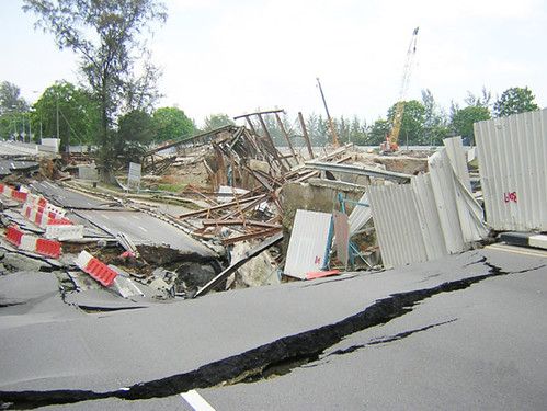 Case Study: The Nicoll Highway Collapse – A Lesson in Design Communication
In April 2004, during the construction of Singapore's MRT Circle Line, a deep excavation site at Nicoll Highway catastrophically failed. Four lives were lost, and extensive damage was caused to nearby infrastructure. The collapse became one of the most significant geotechnical failures in modern urban construction. According to the Committee of Inquiry’s final report, the root causes weren’t just design errors — they were compounded by poor communication of design assumptions, under-communicated risks, and a lack of clarity in the way geotechnical concerns were reported and responded to.
Case Study: The Nicoll Highway Collapse – A Lesson in Design Communication
In April 2004, during the construction of Singapore's MRT Circle Line, a deep excavation site at Nicoll Highway catastrophically failed. Four lives were lost, and extensive damage was caused to nearby infrastructure. The collapse became one of the most significant geotechnical failures in modern urban construction. According to the Committee of Inquiry’s final report, the root causes weren’t just design errors — they were compounded by poor communication of design assumptions, under-communicated risks, and a lack of clarity in the way geotechnical concerns were reported and responded to.
The diaphragm wall and supporting strut system were under-designed for actual soil pressures. Instrumentation data showed early signs of instability — but without clearly defined triggers, action thresholds, or escalation protocols, the opportunity for intervention was missed. — SCOSS/CROSS Safety Report
Why This Case Reinforces the Need for Clear Reporting While this failure wasn’t caused by a single poorly written report, it demonstrates what happens when geotechnical assumptions and responsibilities aren’t clearly and consistently communicated throughout the project lifecycle. This directly reinforces the argument that:
- Geotechnical design recommendations must be unambiguous. Language such as “may be suitable” or “likely acceptable” without qualifying conditions can easily be misinterpreted by non-geotechnical professionals during fast-moving design and construction.
- Assumptions must be traceable. The wall design at Nicoll relied on optimistic soil strength values that were not adequately justified — a reminder of why design inputs should be clearly stated in geotechnical reports, with the relevant test data and interpretations visible to all stakeholders.
- Monitoring and contingency plans must be written into reports. Reports should not only present findings, but also include conditions for further investigation, trigger thresholds for action, and specific monitoring guidance. At Nicoll, although instrumentation was in place, the lack of clear escalation guidance contributed to delayed response.
What Engineers Can Learn Even on smaller-scale projects, the principles remain the same. If your report does not clearly define what assumptions your advice is based on, what conditions must be met, and what actions should be taken if those conditions are not met, you are increasing risk — not just for the client, but for your practice. The Nicoll Highway collapse is a tragic example of how geotechnical uncertainty, when paired with vague or under-communicated design intent, can lead to cascading consequences.
Geotechnical reporting is not just about presenting data — it’s about writing defensible, usable, and accountable recommendations that will be interpreted correctly long after you've left the site.
Best Practices for Global Consistency and Risk Reduction
- Use standardized soil classifications like USCS or AASHTO
- Include conditional statements only when supported by testable criteria or follow-up investigation plans
- Create a “Summary of Recommendations” table for quick review by permitting bodies or project managers
- Add a dedicated “Limitations” section covering data gaps, assumed conditions, and exclusions
- Reference applicable national or international frameworks to bolster defensibility, such as the USACE Geotechnical Manual
Regardless of region or project size, a well-structured geotechnical report is more than a regulatory requirement — it’s a technical and legal record of professional judgment. By clearly defining scope, backing recommendations with traceable data, and eliminating ambiguity, you provide lasting value to clients while reducing your professional risk. If your current report templates or review process don’t yet reflect this level of rigor, now is the time to upgrade them — before a dispute forces the issue.