Borehole Logging Software
Trusted by Engineers
Across New Zealand
TabLogs is the ultimate software solution for creating fast, accurate borehole logs and managing geotechnical data seamlessly. Designed for field and office use, our intuitive platform helps geotechnical and environmental engineers log boreholes efficiently, automate reporting, and ensures compliance with industry standards.


Looking for a gINT Alternative in New Zealand?
With gINT approaching end of support, many New Zealand consultancies are transitioning to modern cloud platforms. TabLogs enables you to import historical gINT data, retain familiar report formats, and move active projects into a structured digital workflow without disruption.
Trusted by leading companies worldwide







Why Geotechnical Teams Choose TabLogs
QA Bottlenecks and Rework
Manual data entry, spreadsheets, and disconnected systems create avoidable errors. Engineers spend valuable time reviewing borehole logs and field records before issuing reports. QA becomes reactive, delaying deliverables and increasing project risk.
Built In Validation and Controlled Workflows TabLogs validates data as it is captured. Mandatory fields, structured logging templates, and real time validation reduce transcription errors and missing information. Your team leaves site knowing logs are complete, consistent, and ready for review.
Inconsistent Logging Across Projects
Different engineers, different formats, different interpretations. Maintaining consistency with New Zealand Standards, NZGS guidance, and project specific requirements across regions and offices becomes difficult.
Standardised Logging Aligned with New Zealand Practice TabLogs enforces consistent logging workflows across your organisation. Structured templates support New Zealand based classification systems and project requirements, ensuring every borehole log follows the same methodology across transport, infrastructure, subdivision, and environmental investigations.
Growth Creates Operational Friction
As your consultancy expands, legacy tools and shared spreadsheets become bottlenecks. Adding users, managing permissions, and consolidating data across offices increases complexity and risk.
Scalable Cloud Platform for Growing Consultancies TabLogs scales with your organisation. Add users, projects, and locations without infrastructure overhead. Centralised project management and controlled permissions allow teams across New Zealand to work within one connected environment.
Digital Borehole Logging, Reporting, and Subsurface Data Management

Field Ready Borehole Logging
Replace paper logs and double handling with structured digital logging built for New Zealand ground investigations. TabLogs provides a fast, button based interface designed for real site conditions, enabling accurate borehole logging that aligns with NZGS field logging practice and relevant New Zealand Standards. Capture soil and rock descriptions consistently while maintaining control over terminology and classification across your projects.

Professional Borehole Log Reports in Minutes
Generate clear, professional borehole logs using fully customisable report templates. Maintain your company’s formatting, branding, and technical standards while delivering consistent outputs across transport, infrastructure, subdivision, and environmental projects. Produce compliant reports quickly, reduce manual formatting, and issue logs with confidence.

Seamless Laboratory Testing Integration
Manage soil and rock samples within a connected field to laboratory workflow. Filter and organise samples by depth, material type, strength parameters, groundwater observations, and project area to generate laboratory test requests instantly. Eliminate rekeying errors between field and laboratory teams and maintain full traceability from borehole logging through to final test results.

High Speed Bulk Data Entry for Office Workflows
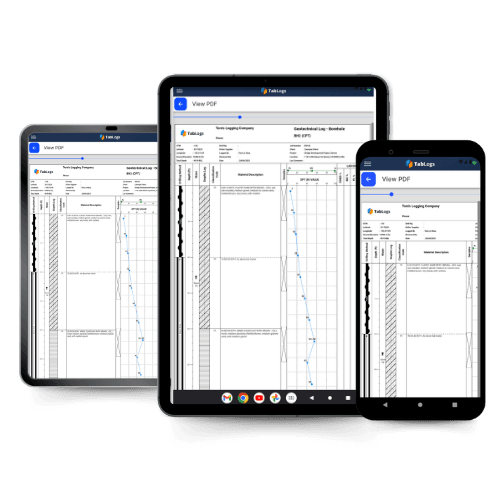
Structured bulk edit tables support fast and accurate data entry for office based teams. Import and digitise contractor logs, legacy PDFs, and historical investigation data with greater control. Edit multiple depth intervals at once, capture SPT results efficiently, and duplicate lithology patterns to maintain consistency across large investigations. Whether operating fully digital, office based, or hybrid field workflows, TabLogs adapts to your process.

3D Visualisation and GIS Mapping
Visualise boreholes within their true site context. Automatically plot investigation points within a 3D model, adjust surface layers, overlay geological mapping, and interpret subsurface conditions across the project area. Improve spatial understanding for earthworks, slope stability, pavement design, and environmental assessments throughout New Zealand.

Data Integration and API Connectivity
Integrate borehole data with your broader project ecosystem. Import and export structured datasets and connect via API to internal systems, client platforms, and reporting tools. Ensure ground investigation data flows consistently between consultants, contractors, laboratories, and asset owners without reliance on spreadsheets or manual transfer.
Trusted by Geotechnical and Environmental Engineers Across New Zealand
400+
Geotechnical and Environmental Companies
1M+
Boreholes Logged Globally
Millions
Metres of Subsurface Data Captured
99.9%
Uptime Reliability
"Tablogs has transformed our workflow by streamlining field data collection and eliminating manual entry errors. By digitising the process, we ensure every log—regardless of the driller—strictly adheres to NZGS field logging guidelines, guaranteeing high-quality, standardised data across the entire team. With data being captured digitally at the rig, we have completely removed the need for manual data entry and ‘clean-up’ back at the office."
Nick Abbott
Griffiths - Wellington




Ready to Modernise Your Borehole Logging Workflow?
Join engineering teams across New Zealand who have moved from paper, spreadsheets, and legacy systems to structured digital logging.
- 14-day free trial with full access
- Dedicated onboarding support
- Import your existing gINT data
Get Started
Chat with one of our geotechnical specialists and get started with a free trial.
Frequently Asked Questions
Everything you need to know about TabLogs. Can't find the answer you're looking for? Contact our team.
Still have questions?
Our team of geotechnical engineers is here to help you get started.